Experience real-time gamma radiation detection and mapping like never before with our cutting-edge robotic payload. Leveraging over a decade of research, our N-Visage Explore product features advanced algorithms that pinpoint radiation sources with exceptional spatial accuracy so that you can make confident decisions, enhancing efficiency in active plant operations and decommissioning processes.
Increase Operational Efficiency
See outputs in real-time to provide immediate on the ground insight into safety without the need for post-processing. Make decisions, fast.
Improve Site Safety
Spot and quantify sources of radiation quickly so that you can keep people away from danger.
Make Confident Decisions
Clearly understand where hot spots are using data with the highest spatial accuracy on the market, so you can decide what to do next.
Respond immediately with real time data
See real-time radiation data through an augmented reality view providing instant on the ground insight into safety throughout your mission, without the need for post-processing.
Respond immediately with real time data
See real-time radiation data through an augmented reality view providing instant on the ground insight into safety throughout your mission, without the need for post-processing.
Powerful insights from outstanding spatial mapping
We’ve designed NV-Explore alongside our partner Leica Geosystems, so that we can offer data with market leading spatial precision helping you to identify small and contained sources such as those in pipe or valves.
Powerful insights from outstanding spatial mapping
We’ve designed NV-Explore alongside our partner Leica Geosystems, so that we can offer data with market leading spatial precision helping you to identify small and contained sources such as those in pipe or valves.
Simple to use, quick to deploy
As gold partners with Boston Dynamics we’ve been able to tightly integrate NV-Explore with their Spot robot meaning you can easily control and see inspection data directly on the controller, making operations efficient.
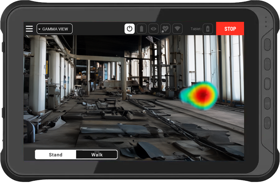
Gamma AR. Radiation is presented as an augmented reality view, visible directly in the environment. Informed decisions can be made with this powerful contextual insight. What is the optimal placement of a lead shield? What is the effect of a recent chemical clean?
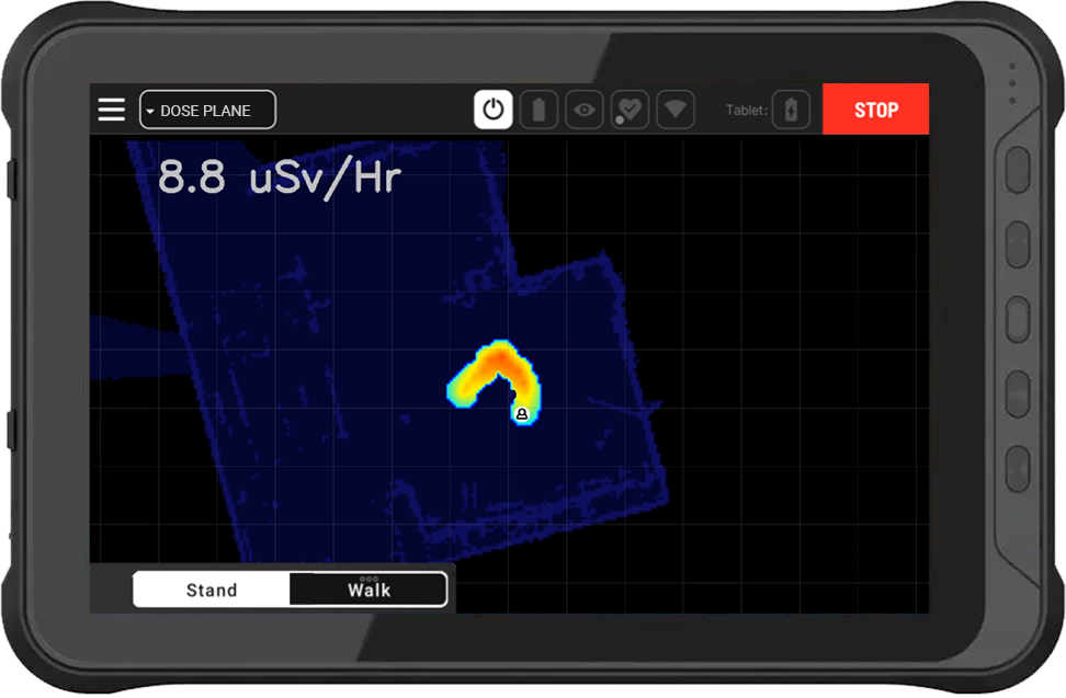
Dose plane. A top down view of the environment displays where the robot has been, helping you decide where to explore next. Dose rates are displayed using a colour scale, making it obvious where hotspots are as well as quantifying their strength.
Dose plane. This features presents a top down view of the environment making it clear where the robot has been, giving clear feedback on where to survey next. Dose levels are displayed using colour. Auto-scaling is applied so it is clear where the most activity is recorded for further exploration.
Gamma AR. Radioactivity is presented as an augmented reality visible directly in the environment. Informed decisions can be made with this powerful contextual insight. What is the optimal placement of a lead shield? What is the effect of a recent chemical clean?
Insightful post mission data
We understand that it is challenging to plan operations in nuclear. It is hard to make decisions about worker safety without all the facts. That is why NV-Explore provides indepth 3D, radiometric data to help decision makers understand and decide what to do with confidence.
Powerful Features
Real-time ‘AR’ and ‘dose plane views’
Createc’s advanced source location algorithms
Outstanding spatial data precision from Leica Geosystems partnership.
Simple UI from tight integration with Boston Dynamics’ Robot.
Post mission data outputs including radiometric 3D point cloud and quantitative radiation measurements.
N-Visage Fusion processing for further insights and quantification.